-
Why does the wind always come from the front and is hard work when cycling?
To distract myself from the annoyance of the headwind, I spend some time thinking about why it is so annoying. The first thing to notice is that there are far more headwind than tailwind trips. This is due to the fact that one si going forward, so wind from the side also feels like a headwind. And depending on the angle between the wind and me, as well as the speed difference between the wind and the cycling, even a slight tailwind can still feel like a headwind. When there is no wind, it still feels like a headwind.
Second, a headwind requires much more strength and energy than you get back from a tailwind. The reason for this is that the drag resistance is proportional to the square of the (relative) speed. From here on I only look at the part of the wind that comes from the front, e.g. the real headwind component.
Assuming that the other friction forces (rolling and sliding friction) are exactly balanced by the wind at 12.5 km/h tailwind, i.e. I am neither slowing down nor getting faster, I can define this force as a unit of friction. (I didn’t measure it exactly, maybe it’s a few km/h more, maybe a little less.) If I cycle at 12.5 km/h in no wind, then I have to apply two units of friction. At twice the speed of 25 km/h there are already five units of friction (2 squared plus 1). With a tailwind of 12.5 km/h and 25 km/h on the bike, it’s down to only two units of friction again. If the wind blows twice as strong and I am therefore exactly as fast as the wind, there is one unit of friction left and only when the wind is blowing at 37.5 km/h from behind do I no longer need to exert any force to move forward. So between 12.5 km/h and 37.5 km/h with a tailwind I only save two units of friction, in case of no wind, between three (67%) and five (100%) units can be saved.
Let’s look at the headwind situation. At a cycling speed of 25 km/h without a headwind, I have to apply five units of friction, as shown above. With a headwind of 12.5 km/h it is already ten units (3 squared plus 1), i.e. twice as much, or 200%. At 25 km/h there are 17 units of friction (4 square plus 1), more than three times as much, and at 37.5 km/h headwind there are 26 units of friction (5 square plus 1). Compared to no wind, I would have to apply 5 times the force. Compared to the savings in the other direction, this extra effort is huge. And that’s why headwinds feel so much worse than tailwinds. I do my commute at about 80% of my maximum strength, I think, which means I slow down very quickly when there’s a headwind because I just can’t produce twice as much or even more strength.
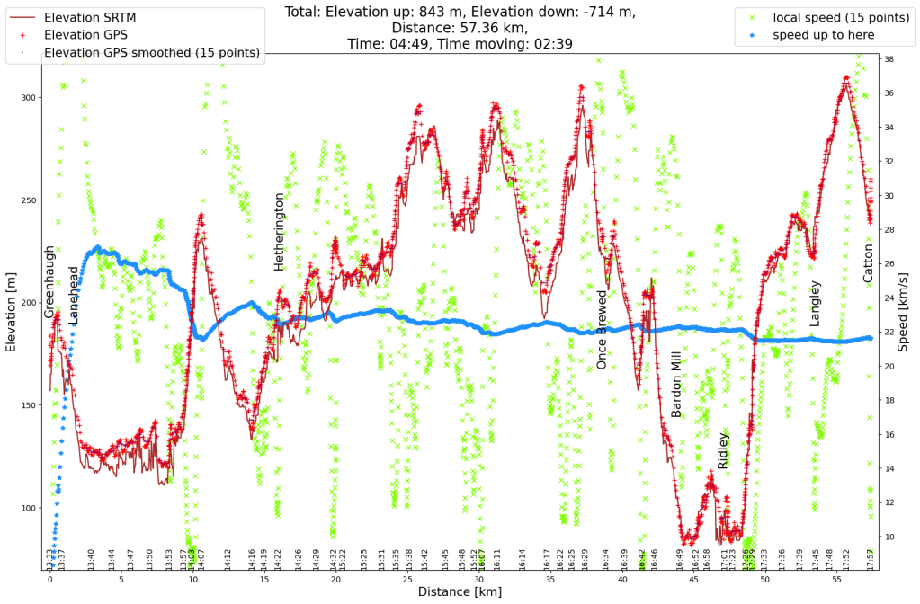
Let’s assume I keep the force the same and adjust my speed to the wind so that I stay at five units of friction. This means I would maintain a speed difference between the bike and the wind of 25 km/h. What would that mean for the duration of my commute if it took me 30 minutes with no wind (my commute to work is 12.5 km long). The table lists the tailwind (TW) and headwind (HW) speeds and duration (min, in minutes).
Wind speed km/h TW km/h TW min HW km/h HW min Total min 0 25 30 25 30 60 5 30 25 20 37.5 62.5 10 35 21 15 50 71 12.5 37.5 20 12.5 60 80 15 40 19 10 75 94 20 45 17 5 150 167 25 50 15 0 very long TW: tail wind, HW: head wind, km/h: speed, min: duration in minutes As long as I’m not lucky and the wind turns in the right direction over the course of the day, wind always means a longer overall journey time, with a wind of just 15 km/h it’s already 50% longer. The data in the table is somewhat idealised, due to potholes and vehicles parked on the road, as well as natural reasons such as intersections and pedestrian crossings, an average speed of over 30 km/h is not feasible. On the headwind side, it helps that the wind is weakened somewhat near the ground by hedges, houses, trees, hills and roads that are not exactly straight. One can also reduce your own cross section slightly, which also reduces wind drag. I also think that I put in a little more effort against the wind and therefore it doesn’t take quite as long.
There are more things to consider about this idealised way of calculations, for example the rolling and sliding friction apply per distance, which means that at higher speeds you have to work against more friction in the same time.
My speedometer states I burn about 35 kcal (kilo calories) per kilometre. Assuming this measurement was done with no wind, my energy consumption doubles with a 12.5 km/h headwind. 35 kcal is 145 kJ (kilo-joules). The energy to lift something is calculated as m * g * h (mass times gravity of earth times height). To lift myself and bicycle one meter, I need about 850 joules or 0.85 kJ. Instead of facing a kilometre headwind, I would rather ride 150 meters uphill. After that it goes downhill again!
-
England cycle trip 2023 (8 – summary)
I traveled to Northumberland (in the north of England, almost on the Scottish border) for an event at the end of March. The week after the event I took leave to explore a little more of England. This is the summary of the bicycle tour. The individual days were:
- from Newcastle into the Cheviot Hills
- from the Cheviot Hills to the North Pennines
- from the North Pennines to the Yorkshire Dales
- from the Yorkshire Dales to the west coast
- touching the South Pennines
- Peak District
- Derby- und Leicester-Shire

Mountains and hills of England: 1: Cheviot Hills; 2: North Pennines; 3: Yorkshire Dales; 4: South Pennines; 5: Peak District. Source: Wipedia: (CC BY-SA 3.0) https://creativecommons.org/licenses/by-sa/3.0/deed.en 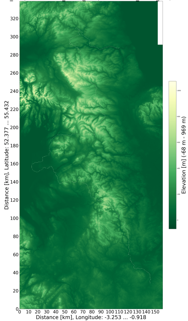
SRTM relief map with GPS data. The bike tour is just visible as a white line. I left out the very highest mountains but otherwise crossed a lot. When I was planning the trip, I had a few concerns: would it be possible to take my bike on the train; I will have irresolvable technical glitches; what if I can’t find any (cheap) accommodation that day. Even though I knew that this would all be solvable, I always felt a little uneasy when I thought about the trip. But in the end none of these problems came up, as usual my worries were much bigger than reality. The mishap I had to solve along the way was totally unexpected and therefore not part of my worries. In the situation, however, I was able to remain very calm (apart from a few seconds).
What I found beautiful were the many animals along the way. Lots of small birds, wild geese, curlews (they look so funny with the very long beak, it made my smile bigger every time), different birds of prey, different species of crows, rabbits, deer. Cycling is still much faster than hiking, so I probably missed many things along the way. I was surprised that the lambs in the north of England had already been born, also because I felt the weather was still very wintry.
Next time I would do a few things differently. The end of March is still too early for England, it’s just too cold and wet. With nowhere to just sit down, the tour wasn’t as relaxing as it could have been. I would also plan shorter daily routes. 10 years ago I cycled along rivers in Germany and managed 160 km a day. On Sundays I ride 100 km between 8 a.m. and 2 p.m. and I’m still not physically exhausted after that. With this knowledge I had planned with 140 km a day. But now I’m a bit older and the terrain was much more hilly. Next time I would plan with 100 km a day. Then you don’t have to cycle from 9 a.m. to 7 p.m., but with more breaks could still be at the accommodation by 6 p.m. And next time I would look a little more for bike paths along disused railway lines.
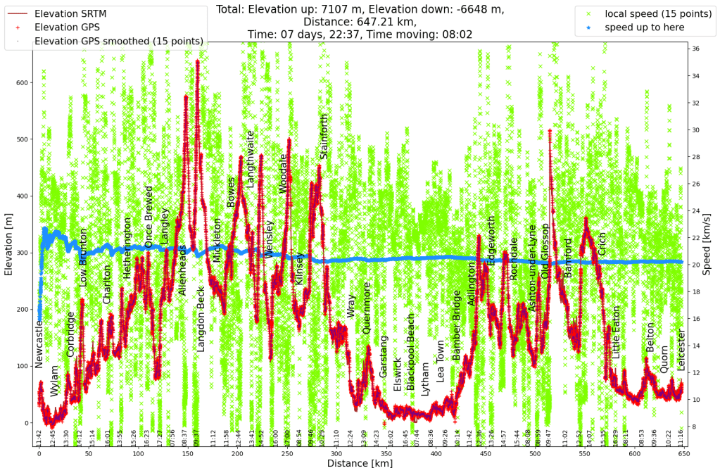
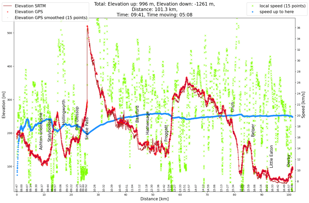
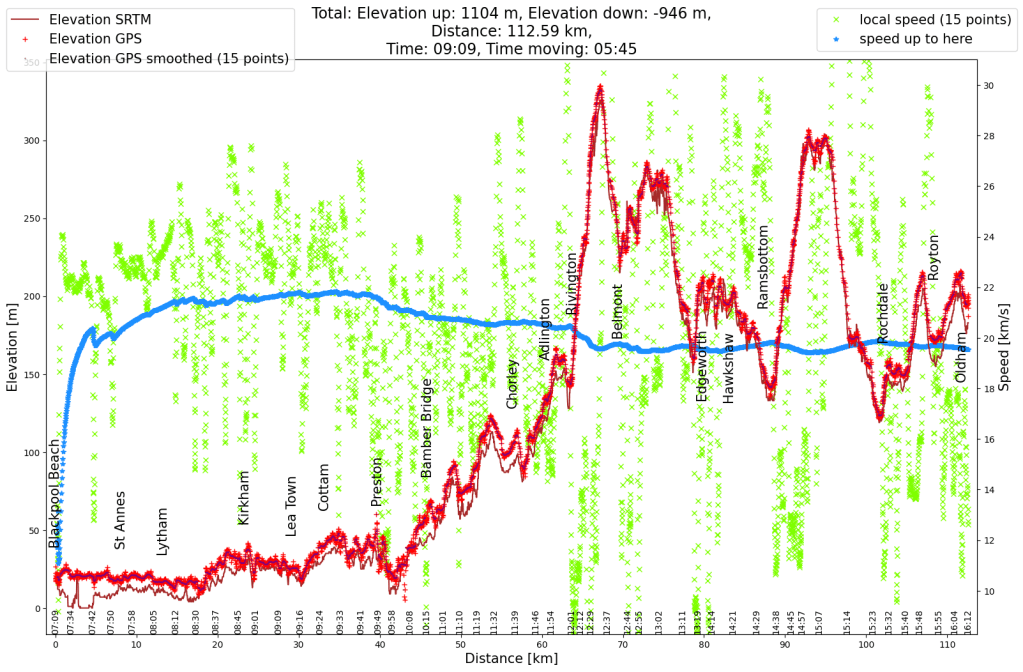
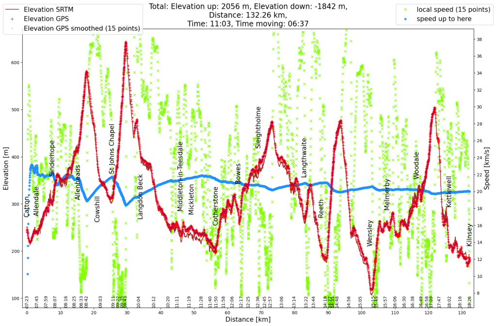
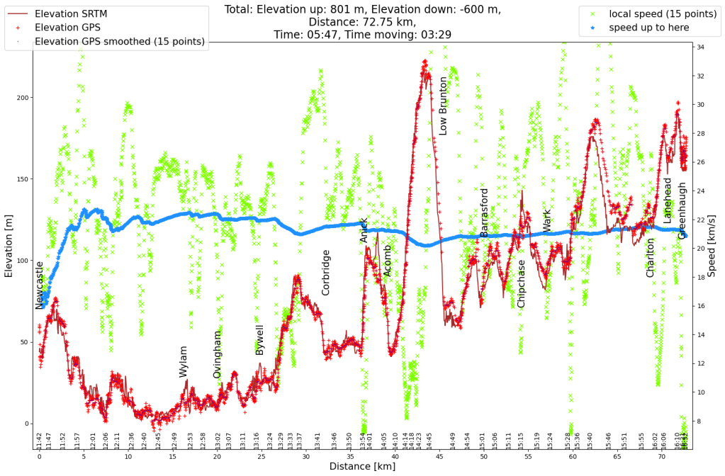
Elevation profile of the entire cycle tour from Newcastle to Leicester. What felt like mountains on the first day were actually just hills. -
England cycle trip 2023 (7)
I traveled to Northumberland (in the north of England, almost on the Scottish border) for an event at the end of March. The week after the event I took leave to explore a little more of England. This is the sixth (and final) day of the bicycle tour.
The sleep last night wasn’t great. In the evening the other guests prevented me from falling asleep (the doors to the rooms closed so loudly and the walls were so thin that I knew exactly when someone came back into the room). In the morning there was street noise in front of the house and at some point the first guests in my hallway went to breakfast. But between all this I always found sleep, I wasn’t so desperate to look for the ear plugs. The breakfast in the hotel was great and so I went back on my bicycle at 9 a.m. well strengthened.
After leaving the city the route went along bike paths, following bike route 6. First it ran along a filled canal, later along an empty canal and finally for a short stretch along the Trent & Mersey Canal. Then the bicycle path switched to a disused railway line. The entire route had relatively flat asphalt, so I made good progress. There was drizzle again and again, but it was so light tht in between I dried off.
At some point the route on the railway line came to an end and continued along small roads. There was only a dirt road between Shepshed and Loughborough and it wasn’t in a good condition after the rain of the last few weeks and days. And so I and the bike got really muddy again. In the residential area after that I didn’t see anyone pottering in the front yard, otherwise I would have asked for some water to wash off at least the worst of the mud. This is where I had to look at the map for the first (and only time) on the way, otherwise the signage was great. The next 15 km weren’t particularly interesting, just a bike path along big roads.
Only in Leicester did the route become more interesting again when the cycle path turned towards the river. Unfortunately, a drizzle slowly set in. I had a light lunch under the trees, then made my way to the train station to see if there was a way to shorten the route. I was lucky and was able to buy a bike space and ticket. And so I was able to relax and meet up with a friend for lunch.
The train ride was easy. The only thing that I noticed was that the bike (or luggage) must have gained weight. Carrying it up and down the bridges was much more strenuous than on the outward journey. Maybe it was just because I put a lot of energy into my legs but not into my arms over the last week.
After saving 70 km by taking the train, I still had 40 km to go for the last stretch home. It was still dry when I got off the train, but as soon as I left the station area it started to rain. I was expecting one short shower and since it wasn’t too cold I decided against the rain jacket. But the rain was heavier than expected and once that was clear, the rain jacket made no sense anymore because my shirt could hardly absorb any more water. Because of this, and by overtaking the standing rush hour traffic, my mood improved significantly. The route began again on an old railway line. Most of this was paved and fine to drive, but the non-paved portion was again quite muddy. At the end of the route, and when it finally stopped raining, I used some of my water to clear the chain of mud again.
The last bit went along well-known paths. What I remembered as a big climb from previous rides was just a small hill today. The training of the mountains was clearly visible here. When I was at the top, I saw the next rain cloud coming and so, after being half dry in between, I got wet again. I was home a little after 6 p.m.
Since the weather wasn’t particularly good and the landscape wasn’t so different from home, no photos were taken on the last day.
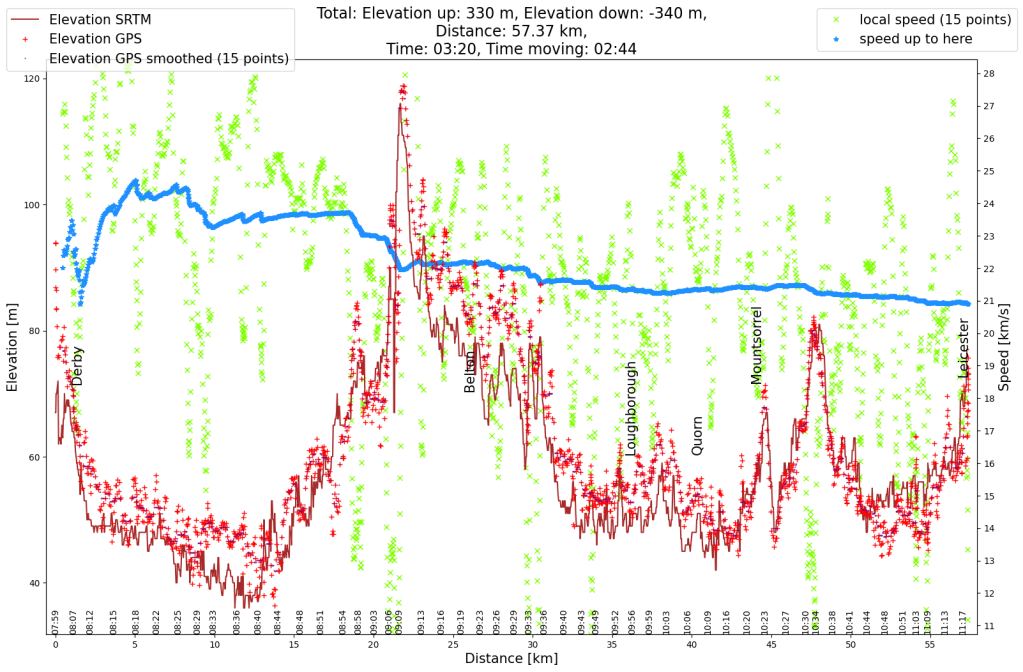
Elevation profile of the cycle tour from Derby to Leicester. It was a tour wich much less elevation then any of the previous days. 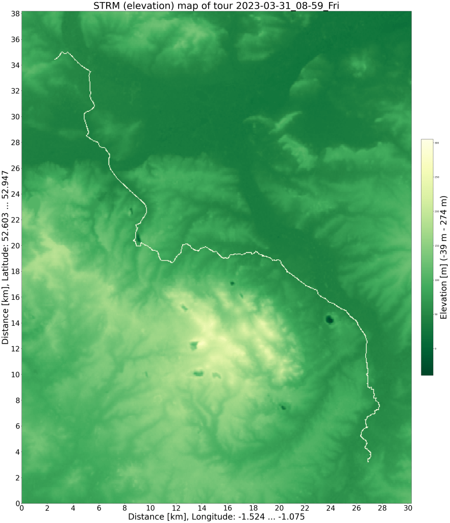
SRTM relief map with GPS data. The quarries are clearly visible, humans are really making long lasting changes to earth. -
England cycle trip 2023 (6)
I traveled to Northumberland (in the north of England, almost on the Scottish border) for an event at the end of March. The week after the event I took leave to explore a little more of England. This is the fifth day of the bicycle tour.
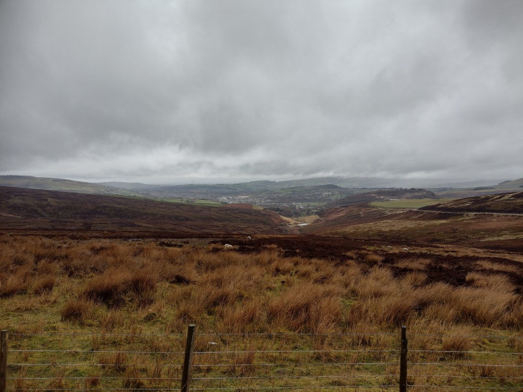
Also on Thursday morning the accommodation didn’t have breakfast, but that was fine with me. So I had breakfast out of my backpack and was looking forward to a café for the second breakfast. The start of the tour was pleasant: dry, downhill, along small roads and finally along an old railway track. Unfortunately the drizzle was already starting there, and the rain radar indicated that putting on the rain jacket would be worth it. The profile remained pleasant up to Ashton-under-Lyne and Stalybridge, then the first hills of the Peak District set in. On the second climb I look at the map to see if I could take a flatter route. However, having to cross a lot of rivers would have meant I would probably have had a lot of ups and downs and so I stayed on the route into the Peak District.
Ascent from Glossop to the Peak District. There are still 200 meters of altitude difference over 3 km to Snake Pass. Where the road bends around the hill (at the left edge of the picture) marks about half of the remaining ascend. The next photo was taken from there. At least the rain stopped in Glossop. I tried to avoid the main road a bit more, which allowed me to stay in the beautiful valley of the Glossop brook, but the dirt track was a bit muddy than I had hoped. The road was pretty empty after all, with only a few cars a minute, which I learned as soon as I went on it.
Looking back towards Manchester from Snake Road with Glossop in the foreground. The weather was gray and the clouds hung low. Nevertheless, the view was surprisingly good, the skyscrapers of Manchester were visible slightly. On the right edge of the picture you can see the street from which I took the previous photo. At the end of March, spring had not yet arrived at 400 meters above sea level. 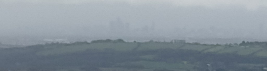
View of Manchester from Snake Road with lots of digital zoom. You can just make out the outlines of the skyscrapers. Reaching this pass released some feelings of happiness, as I experienced with all the passes before. The view was a bit dreary though, very grey. The ride into the valley was great, for a long time it was downhill, first a bit steep, then a bit flatter towards the reservoir. There were few houses and no café. I hadn’t seen any in Old Glossop and I was getting hungry.
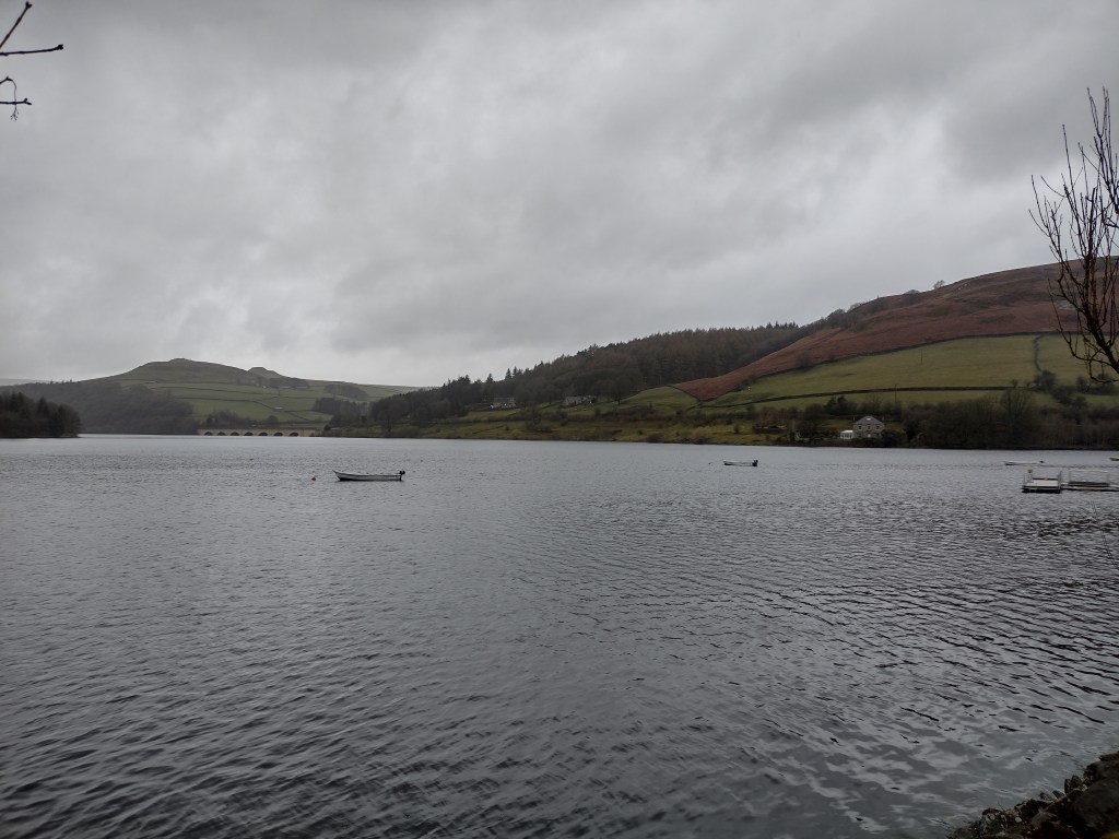
Ladybower Reservoir on a rainy March afternoon with Ashopten Viaduct I knew from friends that there should be a café near the reservoir, but I learned there that it was a bit further away than I thought. Luckily downstream. But first it got wet again from above. It was already lunchtime when I finally got to the café. And since I was hungry I took the extra large Full English Breakfast. I didn’t see the cakes until I paid, a normal breakfast and cakes would certainly have been also delicious.
When I left it was still cloudy and I was expecting rain, but instead the sun came out. Shortly thereafter I packed away the rain gear and a little later even switched to shorts. That was unexpected (and as of this writing, it’s still the only time this year).
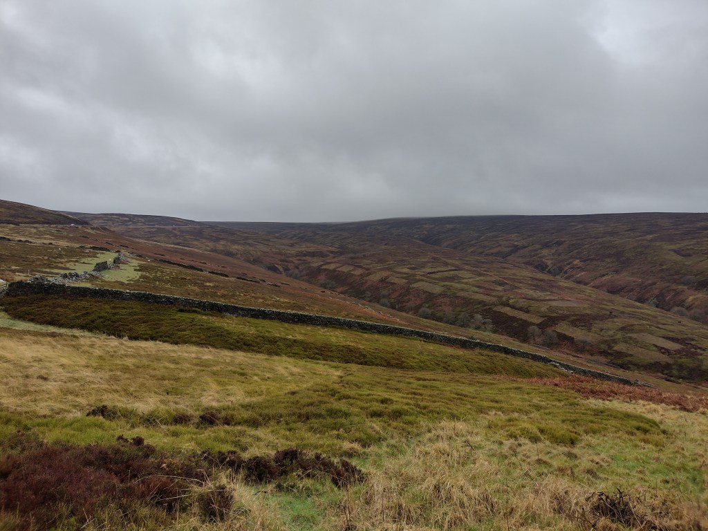
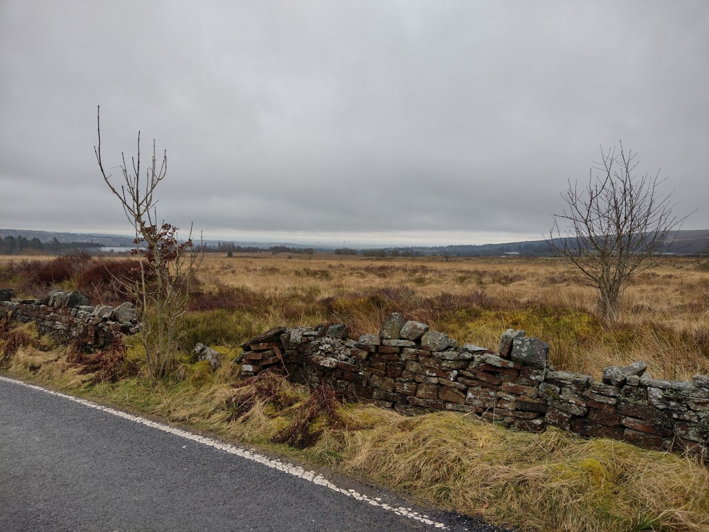
The roads in the Derwent Valley (still the same valley since the Snake Pass) looked pretty busy on the map, so I chose the small roads on the ridge. But for that I had to climb a bit again. And again a sign said the road in front of me was closed, but I was lucky this time too. And got this amazing view:
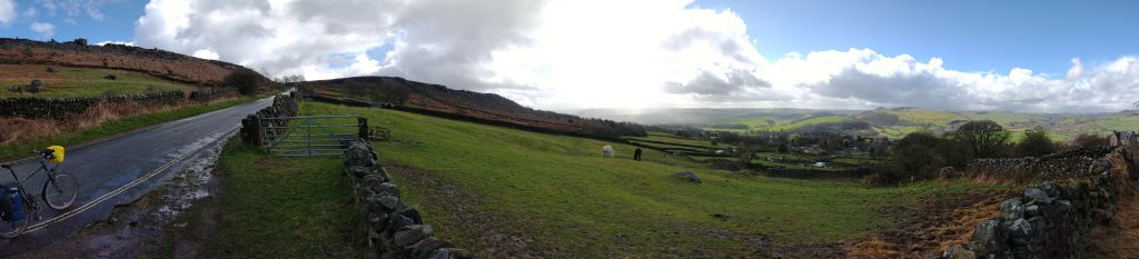
180 degree panorama of the Derwent valley above Curbar. It’s raining on the left of the picture, the sun is shining brightly on the right. The wind came from the side, so it helped at times and sometimes made the path more difficult. The outlook remained interesting. I saw a rain cloud coming my way and was able to wait for it in a somewhat sheltered spot (and change back to long pants). Overall I found the constant ups and downs tiring and was surprised to see in the elevation profile that I was going down more than up. In the middle of the afternoon I found another wall for the second lunch. That’s where I booked the accommodation for Derby when it became clear that I wasn’t going to get any further today.
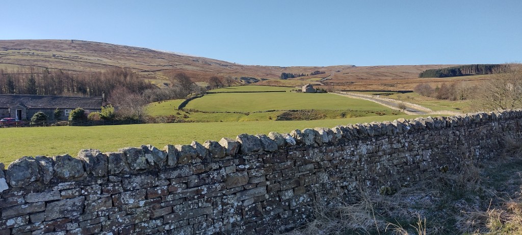
It was a bit annoying that the descent through Fritchley was so steep that I had to brake, and then on the other side of the valley I went up another 100 meters to Belper. Luckily it was mostly flat after that along the valley until I reached the old town of Derby. It felt a bit strange that the old town was almost deserted at 17:45. But as soon as I reached the ring road the traffic was like any British (or German) city. The hotel was good with a noticeable difference in appearance between the front and back.
After the shower I took a little walk to find dinner. And spent a lot of time checking train connections as it was clear I wouldn’t be able to complete the remaining distance in one day. The difficult thing was again booking the bike (not possible online, but necessary) and I had three different options to shorten my bike tour on the last day. I ended up not booking anything but hoping to do so at Leicester train station.
Elevation profile of the cycle tour from Manchester to Derby (unfortunately, the GPS logging failed twice). 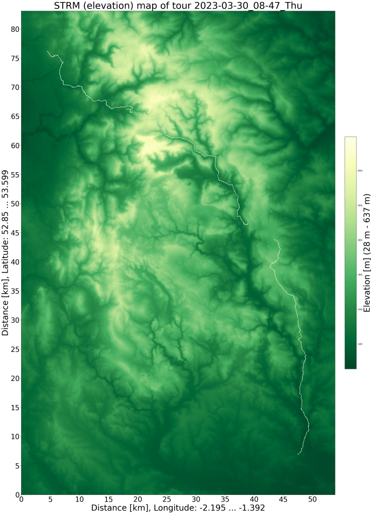
SRTM relief map with GPS data -
England cycle trip 2023 (5)
I traveled to Northumberland (in the north of England, almost on the Scottish border) for an event at the end of March. The week after the event I took leave to explore a little more of England. This is the fourth day of the bicycle tour.
This time the accommodation didn’t include breakfast, but that was fine with me. I had breakfast out of my backpack and was looking forward to a café for the second breakfast. The tour started along the beach promenade, against the wind.
End of Blackpool seafront and start of the dunes on a grey March day When I finally turned west, the wind became a little more bearable. Bike path led me along small streets until just before Preston, where I lost it in a construction site and added a slight detour to my cycle. Big cities are always a bit more difficult to navigate, there are just too many intersections. Preston itself ende surprisingly: downtown – park – old railway line, all within 3 minutes. Since I got hungry, I was a bit annoyed that I gave one breakfast option earlier a pass. But luckily I found a spot at the end of the old railway line and enjoyed another vegetarian full English breakfast.
After that it was mainly through towns and slightly uphill until I finally turned onto the southern edge of the South Pennines and Cycle Route 91. Suddenly the villages became rare and small, but roads went more uphill and downhill. I crossed various creeks that all ended up leading to Manchester and each creek was in a valley. But the landscape was worth the somewhat more strenuous cycling.
View of Manchester from Stones Bank Road. The weather was grey and the clouds hung low. Nevertheless, the view was surprisingly good. At the end of March, spring had not yet arrived at 250 meters above sea level. 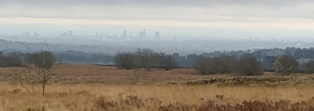
View of Manchester from Stones Bank Road with lots of digital zoom. Towards the end of the bike tour, also because I still had time, I left off the planned route again and rode to Ramsbottom before turning south-east again. This added another hill, there was already significantly more traffic here. In retrospect, I saw that cycle path 92 might have been a nicer alternative. The last bit to Oldham was along main roads, but traffic-wise it wasn’t too bad. This was the only accommodation I booked prior to my trip.
Wind Turbines in the South Pennines, north of Manchester. I had already arrived at 5 p.m. This time after the shower I got back on my bike to meet friends in Prestwich. The 15 km there, without luggage, was very relaxed, even though the bike felt surprisingly wobbly. The way back was wet, it was pouring heavily. As soon as you can no longer get wet and it is sufficiently warm, rain can also be fun. After a good meal and a pleasant evening, together with little traffic on the roads, I was very relaxed.
Elevation profile of the cycle tour from Blackpool to Manchester. 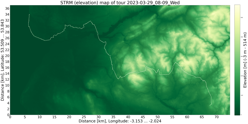
SRTM relief map with GPS data -
England cycle trip 2023 (4)
I traveled to Northumberland (in the north of England, almost on the Scottish border) for an event at the end of March. The week after the event I took leave to explore a little more of England. This is the third day of the bicycle tour.
For four nights I spent in sparsely populated areas with a dark night sky (little light pollution). And only on the last evening I had the chance to see a few stars. But the first clouds were already arriving, which would then determine the third day of my bike tour. In that regard, it was fortunate that the previous tour in the sunshine was a little longer than I had hoped, allowing me to see more of the countryside in the sunshine.
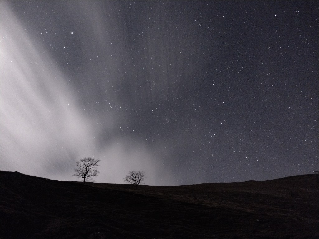
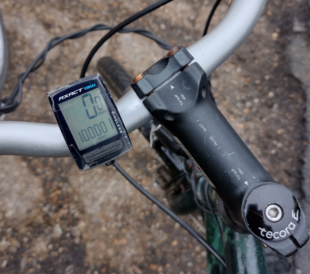
The first clouds of a large cloud area, illuminated by a thin crescent moon, complement the composition of the starry sky over a quarry with bare trees But first I had to take care of my gears, which had given up yesterday, just before the finish. During dinner I had thought a bit about the reasons and possible solutions. Luckily it was the simpler problem, which I was able to solve with two plastic discs cut out of the yoghurt cup of my first dinner on yesterday’s tour (at least temporarily, while I’m writing this I’m waiting for the ordered spare part, which after a good 100,000 km became necessary after all). After repairs and breakfast (vegetarian Full English), the ride finally started at 9:45.
The clouds hung low at Arncliffe, later I almost reached them. Luckily the rain that fell was not too heavy. On the map it looked like I would go up the mountains along a creek again, but the valley was probably too narrow, so the road climbed steeply for 200 m. In addition, it was closed, but I hoped that I would be able to get past the road works site on my bicycle. And I was lucky. Because of the construction traffic, I met more people on this street, otherwise I would probably have been alone again for longer periods of time. After crossing the moor, it was pleasantly downhill ride again, with a short climb because the road crossed a river.
The terrain then flattened out slightly as I left the Yorkshire Dales. I was also fortunate in planning that there is no road crossing the Forest of Bowlands in an east-west direction (otherwise I would definitely have chosen it), so I skirted this mountainous area north and west along cycle routes 69, 90 and 6. The tour from the previous days made me a bit slower but taking breaks wasn’t something I craved either due to the rain. Finally I found a dry spot under a tree to have lunch. In the afternoon it became a bit drier, with breaks between the showers. On the other hand, when the route went south, I had a pretty strong headwind, which is why my mood was still not the best. A second lunchtime under another tree helped a bit, but it really got only better as Garstang got closer, knowing there will be a cafe there.
In the café it became also clear that I could only reach the originally intended destination Southport after 7 p.m. As an alternative I booked accommodation in Blackpool instead (not even a 5-minute walk from the beach, this was the cheapest hotel of the trip). Strengthened, without rain and with less headwind, I got there an hour and a half later, just after 6 p.m.
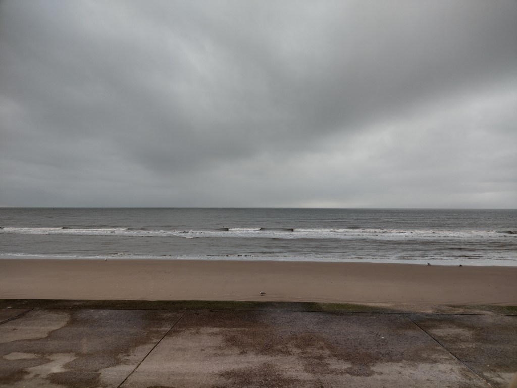
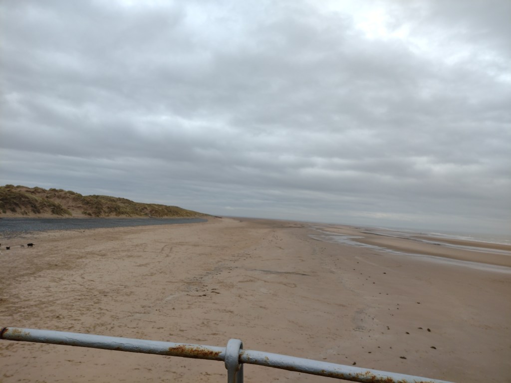
Blackpool beach on a grey March day Unexpectedly, after dinner in town, I spent a long time at the beach. But first I got some more clothes from my room, at 10°C I needed several layers to stay warm in the wind. It was low tide, so there was a lot to see in the sand, and at the same time I used the time to talk to friends on the phone. The time at the beach was very relaxing, I didn’t have to go anywhere, I had time.
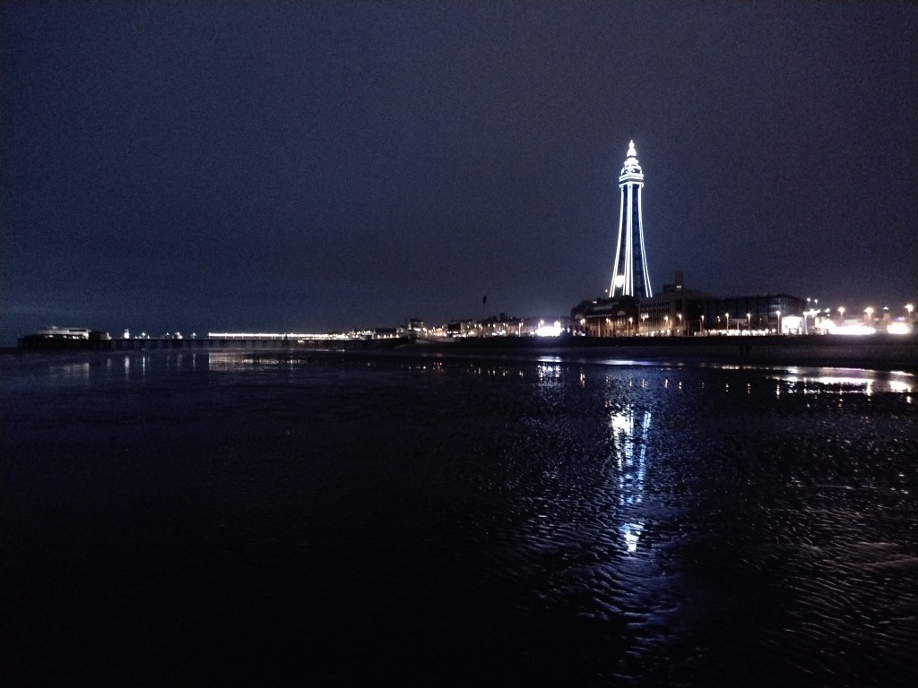
Blackpool tower and North Pier and lots of beach at night. 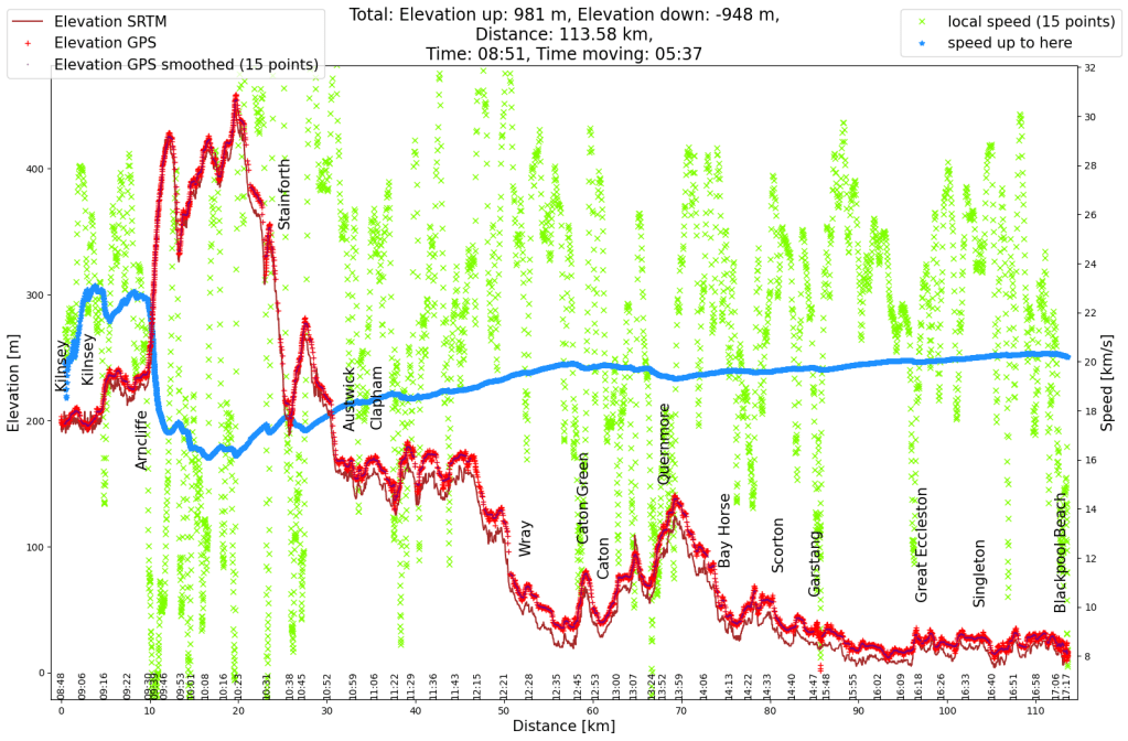
Elevation profile of the cycle tour from the Yorkshire Dales to the coast at Blackpool. 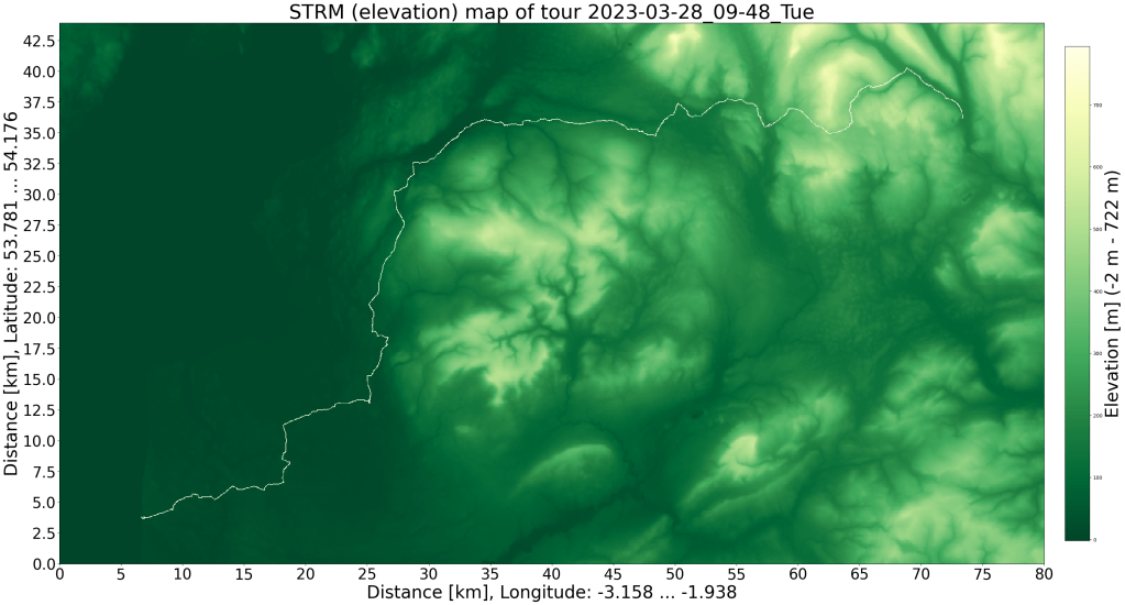
SRTM relief map with GPS data -
England cycle trip 2023 (3)
I traveled to Northumberland (in the north of England, almost on the Scottish border) for an event at the end of March. The week after the event I took leave to explore a little more of England. This is the second day of the bicycle tour.
A little later than I had hoped, after a comfortable night and a full English breakfast, I was back on my bike at 8:30 a.m. and continued cycling in the valley of the East Allen. The late start also had an advantage: the sun was able to warm up the streets a bit. On the previous day there was another sleet shower and during the night the temperature was below 0°C. The sunshine made up for the cold weather.
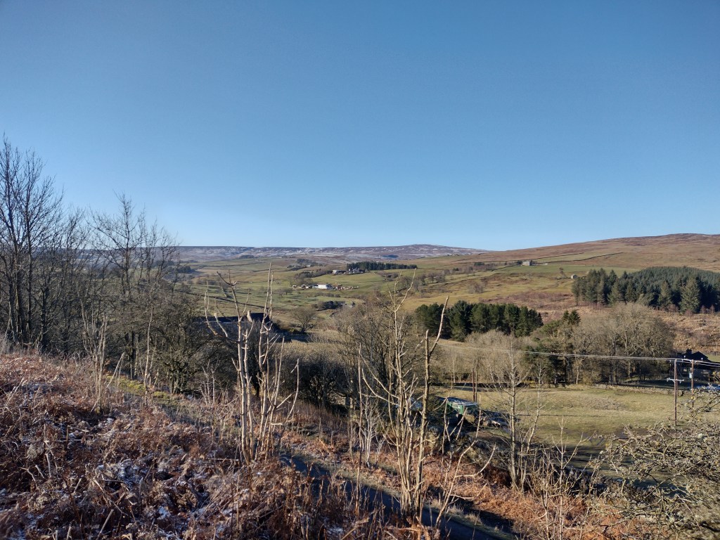
Still very wintry landscape in Northumberland (England) near Allenheads. Somewhere on the left edge of the picture I will cross the mountains, which had a light layer of snow. But I didn’t know that when I took the picture. The slight incline kept me warm and since the streets were so empty I was lokking for a way to share my excitement. And so the time-lapse video below shows the last kilometer to the pass, which is also the border between Northumberland and the County of Durham.
The view all around was great (180° panorama), very alpine, although I was still just at under 600 m altitude. According to the definition from friends, that was also the first mountain: There are no more trees growing on the summit. The highest saddles of the North Pennines were all white. I came from the right and soon will go down to the left. The descent into the valley of the River Wear was fun. After a few kilometers in the valley, however, I wondered why I planned the route the way I planned it. The ascent to the next pass became visible.
View from St. Johns Chapel to the next pass: Harthope Road. The change between the meadows and moor above are always nice to look at. At the top I passed the highest point of the entire tour. The view from this pass was similar to the first. And this descent was great too. This time the tour stayed a little longer along the valley. And suddenly there was a lot more traffic and tourists due to the proximity to High Force Waterfall. However, I didn’t do the small hike to the waterfall, I was more looking for a cozy place in the sun to have a second breakfast, which I ended up enjoying sitting on a wall.
From then on the landscape became hilly, I found myself on the border between the North Pennines and the Yorkshire Dales. I went a short distance along an old railway line. But the experience was disappointing. Although the ground surface was mostly okay, all bridges were removed and every time you crossed a (non-public) field path you had to go through two gates. There were about 14 to 20 gates over 3 kilometers, a lot of stopping.
Cycle Route 70 took me into the Yorkshire Dales. What started as a small road got narrower and became a good gravel road, then a gravel road with lots of holes and finally washed-out gravel. I probably used more energy there for 4 km than for 20 km of road. The nice part was, that again I was really alone there. No houses to be seen, no cars or other machinery to be heard, just a few birds on the heath. And what was very positive was that afterwards I was able to consciously enjoy the asphalt paths again.
And on this, cycle path 71 led me back to the next valley, where I could refill my carbohydrates in a café. After crossing the river Swale the tour went up to the next bog. When looking for lodging at my second breakfast I was hoping to find somewhere in the next valley to stay, however everything I found was above what I wanted to spend. And so I booked accommodation that was one ridge further away. So the lowest point of the day was not the end of today’s tour. Instead I was able to explore the Yorkshire Dales National Park.
When I started cycling up the Cover River valley I was in good spirits. It was already 5 p.m., but mostly sunny. I enjoyed another meal on a wall before passing the last few houses and courtyards. For the next 5 km I again met no one on the road and enjoyed the tranquility and scenery. As usual in these valleys I had no phone signal, which at 6 p.m. doesn’t feel quite as relaxing as 3 p.m.

Looking back (east) down the Cover River valley at about 400 meters. Another 100 meters and I’m on the pass. But since I also knew that it would take me a maximum of 15 minutes to climb 100 meters in altitude, it was also clear to me that I would arrive at 7 p.m. without any problems.
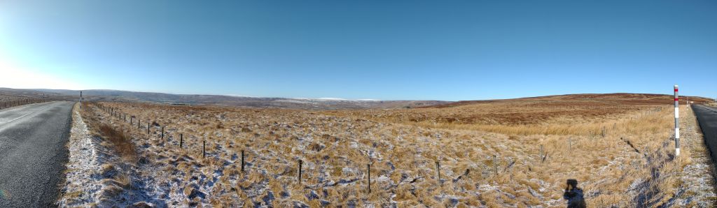
Looking south-west from the pass, down the valley of the River Wharfe and towards the surrounding mountains of the Yorkshire Dales. Parts of the ride down into the valley was again very enjoyable. Only the section with a 25% gradient was simply too steep. I prefer wind resistance as a brake, but if it’s too steep you have to brake yourself. And with that, I’m destroying the work that I previously put into driving uphill (or better: converting it into warm wheel rims).
From here it could have been a relaxed few minutes to the accommodation, but the gearshift threw a spanner in the works and refused to change to higher gears. In first gear, flat stretches would have become very tiring. But fortunately I was able to change gears directly on the hub, so that I managed the last stretch to the accommodation alright by setting it to a middle gear. After a shower I also found a pub for dinner.
Elevation profile of the cycle tour from Northumberland into the Yorkshire Dales. Compared to yesterday’s tour, it is now mountainous. I probably managed 2000 meters of altitude difference over 130 km the last time while living on La Palma. 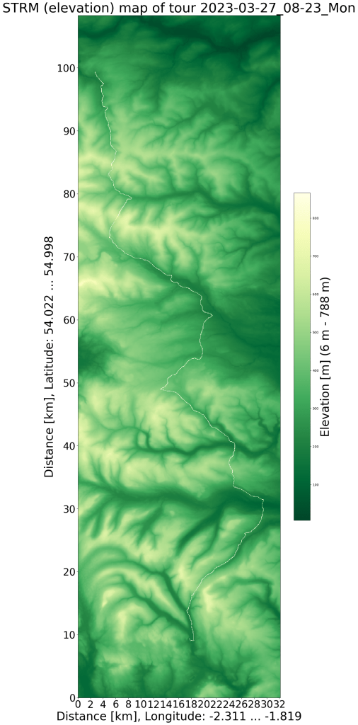
SRTM relief map with GPS data -
England cycle trip 2023 (2)
Still very wintry landscape in Northumberland (England) near Bellingham. The nice thing about cycling uphill is that one can see more and more of the landscape. In this case the snow-capped mountains of southern Scotland are visible in the far distance. I traveled to Northumberland (in the north of England, almost on the Scottish border) for an event at the end of March. The week after the event I took leave to explore a little more of England. This is the first day (half day) of the bicycle tour.
It started in the valley which was already quite green. Apart from daffodils, there was very little spring in sight. But at least it was 8°C, so I could go without gloves. For most of the day I followed bike route 68, which took me to remote areas among many flocks of sheep. That was exactly what I wanted, a relaxed bike ride without being bothered by traffic. The small roads were in good condition (precisely because there is so little traffic on them). I saw a few motorbikes (due to an event) but other than that it was very quiet.

Somewhat surprisingly, the surface changed from asphalt to gravel on cycle path 68. But the path was still in good condition for most of the way, only in a few places the very wet March was noticeable. And it got very quiet, for the next hour I saw two vehicles, otherwise it was deserted. After a last hill I reached asphalt again. The rougher ground and the hills demanded more energy at 5 p.m., I was able to enjoy the meal with a great view. It was only a bit wet to sit down, but I was sitting for the two hours before that in the bicycle anyway.
I loved the landscape, boggy, hilly, stone walls, meadows and a few trees.

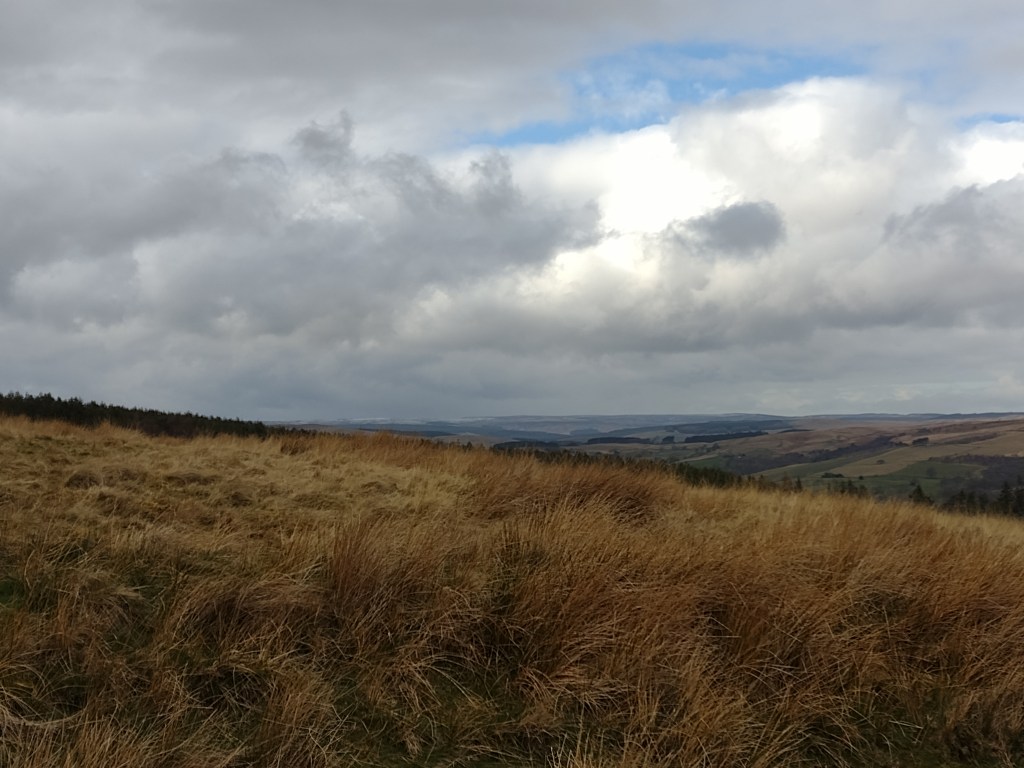
Countryside near Once Brewed (I like the village name). The folding of the mountains has left an interesting landscape: steep edges of the mighty rock strata to the north and relatively gently rising plains to the south. This was part of Hadrian’s Wall, a Roman fortification against the Scots. A little later I passed the Vindolanda Fort. I thought all I had to do was head down the valley and then maybe a few yards up the River Allen to get to my accommodation (I booked that same morning when it was clear when I could roughly leave). I should have checked the altitude difference on http://www.opencyclemap.org/. I crossed the river Allen at the lowest part of the day’s route, but before the accommodation I also had to cross the highest point of the day. So I didn’t arrive until 7 p.m. (and about an hour later than planned), but thanks to the time change, the sun hadn’t even set yet. And I arrived before the shower of sleet.
Elevation profile of the Northumberland cycle tour. It’s a hilly landscape. 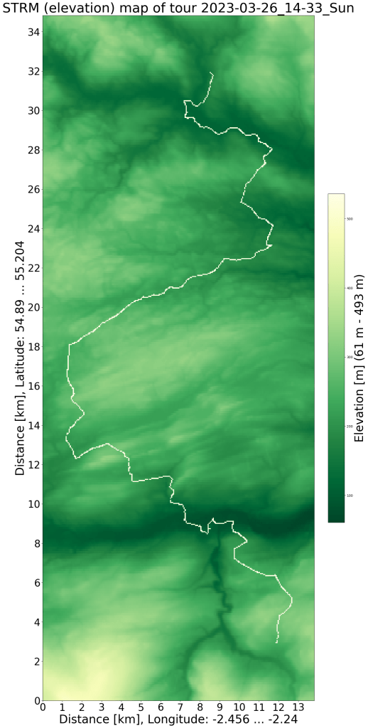
SRTM relief map with GPS data -
England cycle trip 2023 (1)
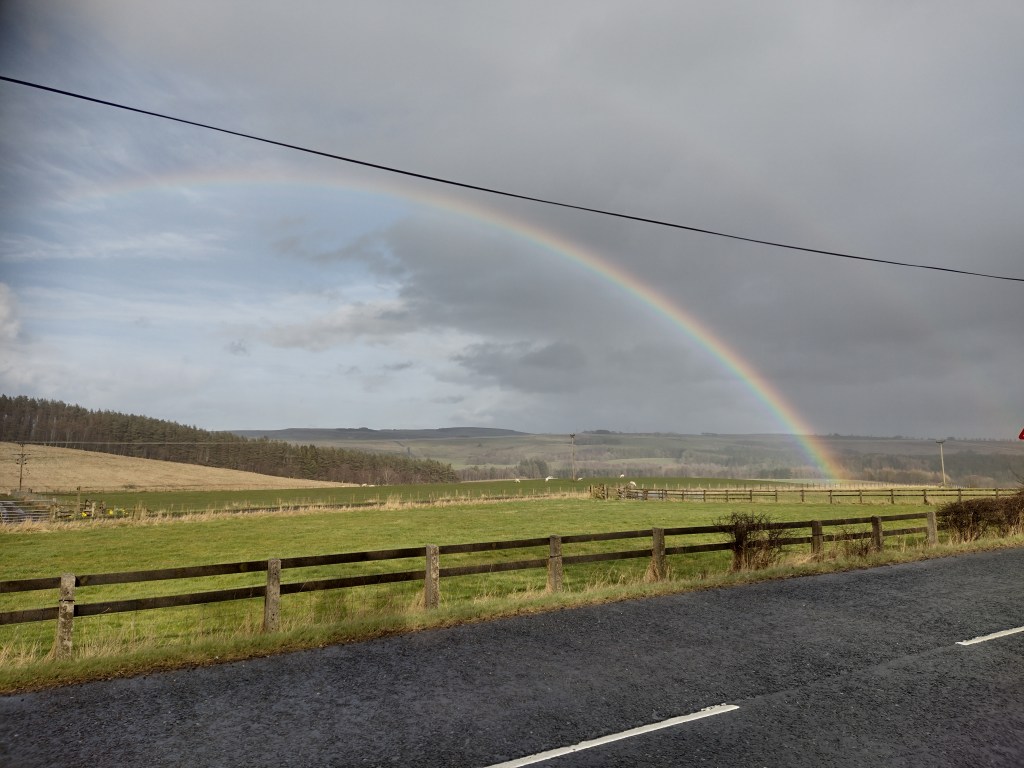
Rainbow in Northumberland (England) between Wark and Bellingham. It’s not the best composition as it was taken from the position where I could stay the driest. I traveled to Northumberland (in the north of England, almost on the Scottish border) for an event at the end of March. Getting there consisted of a train journey to Newcastle and some cycling to the destination. I was a bit dreading the bicycle space reservation. However the call to LNER customer service was quick and unproblematic. And so I was able to get on my bike in Newcastle at 12 o’clock on time on a Friday and saw that the surrounding hills are a bit higher than those near where I live.
However, there were two setbacks: The wind blew in my face and contained water droplets. Luckily, the rain wasn’t a problem as it didn’t last long and the wind and sun allowed for quick drying. It rained a few more times over the 70 km, but only so much that I only got a little wet on the outside.
I left Newcastle on Hadrian’s Way (bicycle route 72), a cycle path that initially led along an old railway. The tarmac was questionable in a few places but mostly fine. After the railway line I continued along the River Tyne and finally along small roads until I turned north just before Hexham.
When planning the route, I wanted to avoid big roads, but what I wasn’t aware of was that the small roads had a lot of altitude. They don’t go all the way over the tops of the surrounding hills, but 80% are hard enough. And so I went up twice before I got back to the river. Since the traffic here is much less dense than at home, the main roads would have been OK. But I only noticed that when I had to use it for a short time and was much less overtaken than expected.
Elevation profile of the Newcastle cycle tour. I could have saved myself the hill to Anick and in front of Low Brunton. On the way I was able to talk to another cyclist, because we were traveling in the same direction at a similar speed. However, there were not many people on the road overall, so this encounter was lucky.
The interesting thing about the rain was that you only had to find a tree trunk to stay reasonably dry. At the end of March the crowns were still empty, but the wind was so strong that the rain came from the side and not from above. I was lucky enough to find a tree in time during the heaviest showers, also because the landscape was so wide that you could see the showers a few minutes before arrival. Rain and sunshine created the beautiful rainbow in the cover photo.

SRTM relief map with GPS data -
Endurance
My bike will be 15 years old in June, but it has already reached a milestone today: 100,000 km. For this I sat on the bike for 4340 hours (about half a year) and was on the road 3154 days. (By now it should be clear that I like numbers.) Only 522 times was the daily distance over 50 km (133 times over 100 km, 33 times over 150 km, 7 times over 200 – Benford’s law) and half of the days the distance was under 19 km (journey to work, shopping). On average, I rode 32 km on days when I was on my bike. The bike has visited a number of European countries: in addition to Germany, England and Spain, I have been to Sweden, the Czech Republic, Slovakia, Italy, Austria, Switzerland and France, between 28.5° and 59.5° north and between 18° west and 20.5° east .
Not many components are still original, apart from the frame, there are still the handlebar stem, luggage rack, taillight, cranks and the rear wheel hub. Although I’m a bit disappointed with the latter one, the Rohloff hub had to go to the manufacturer twice because a couple of gears slipped. The need to quickly change gears in city traffic when starting at traffic lights was probably the problem.
My data on the bike can be found at http://ronnyerrmann.ddns.net/ (not always online).
The next milestone is a bit further away, after circumnavigating the earth almost 10 years ago and the 100,000 km now, the next point would be the route to the moon (384,000 km). That would, at the current rate, fall on my 95th birthday. I think I will only look forward to 111,111 and 123,456 km for now 🙂

-
Subscribe
Subscribed
Already have a WordPress.com account? Log in now.
